Red Routes scheme being considered in 2 more areas of Luton after pilot judged a success
and live on Freeview channel 276
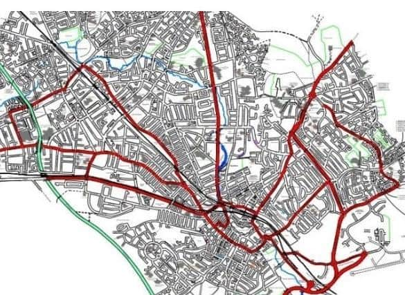
Dunstable Road, Leagrave Road, Dallow Road, Hatters Way, Vauxhall Way, Wigmore Lane and Crawley Green Road could all be included in the next phase.
The experiment began on Airport Way in November 2018 and was extended into parts of the town centre last January.
Advertisement
Hide AdAdvertisement
Hide AdDuring the first nine months, 4,800 motorists in Luton were issued with fines, with more than 3,000 caught on camera.

Currently 60 per cent of fines have been paid, while “the rest are going through normal procedures,” according to the council’s network and safety manager Christine Davy.
Vehicles are forbidden to park or wait along red routes, which are monitored by CCTV and marked by double red lines.
The borough council’s overview and scrutiny board was asked to comment on the possible extension of red routes in the town.
Advertisement
Hide AdAdvertisement
Hide AdBut some of the documentation was not included in the agenda for councillors, so the issue was deferred until a further meeting arranged on Thursday (March 12).
This will enable the board to make comments and any recommendation to the executive.
The network and safety manager told the board that temporary barriers introduced along Airport Way “have resulted in a substantial reduction in penalty charge notices” (PCNs) issued.
“Red routes have been successful in reducing the amount of inconsiderate and illegal parking, although it has made deliveries in the town centre more difficult,” she said.
Advertisement
Hide AdAdvertisement
Hide Ad“Following the success of the pilot scheme, it is recommended strategic routes are considered, subject to funding being available.”
Making Airport Way and the town centre schemes permanent would cost around £1,000.
Liberal Democrat Barnfield councillor David Franks said: “These red routes wouldn’t have been necessary if the council had been fully enforcing the yellow lines which are there already.
“I said that before and nobody listened. My understanding is red routes are to reduce congestion where this is caused by parked vehicles.
Advertisement
Hide AdAdvertisement
Hide Ad“The Dunstable Road stretch between Inkerman Street and Telford Way is congested, but it has nothing to do with parking.
“The only road where congestion was caused by parking was Wellington Street.”
Liberal Democrat Wigmore councillor Peter Chapman agreed it was when the barriers went up near the airport that there were fewer parking issues.
“If we’re suggesting barriers all the way down Dunstable Road similar to those along Airport Way that’s a big decision to make,” he said.
Advertisement
Hide AdAdvertisement
Hide Ad“And it’s impossible to park up Gordon Street because of the building work on new flats.
“To take this as a reason to extend red routes, it’s massive. I wouldn’t want to be responsible for that mistake.
“The new councillors weren’t involved with the original decision and really should see this map.
“Dunstable Road along to the motorway, Leagrave Road to Leagrave, Hatters Way … there’s no parking along it anyway,” he added.
Advertisement
Hide AdAdvertisement
Hide Ad“This includes New Bedford Road, Wigmore Lane and Crawley Green Road. People live there.
“The red routes haven’t made a massive difference.”
Liberal Democrat Stopsley councillor David Wynn said he could see no justification for Vauxhall Way to be included.
Liberal Democrat Sundon Park councillor Anna Pedersen, who chairs the board, said: “We can’t make a decision based on this without the relevant map.”
The issue is due to be considered by the executive on April 6.